Echo Summit off-limits to cars for 2 weeks starting May 11
Caltrans today announced it will temporarily close Highway 50 at Echo Summit for two weeks beginning May 11.
This means the route to the South Shore will be less direct for those coming to the area for the Amgen Tour de California cycling event May 15.
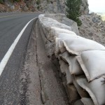
The closure is part of the first stage of a safety enhancement project that will remove damaged rock walls and replace them with a barrier that meets current safety standards. The project is funded in part ($1.9 million) by the American Recovery and Reinvestment Act of 2009.
There will be one-way controlled traffic on May 9-10, and Mondays through noon on Fridays for up to six weeks after Highway 50 is reopened.
The highway will be open with no restrictions on Memorial Day weekend.
Alternate routes around the closure take travelers through the Gold Country of El Dorado and Amador counties. Motorists should allow approximately one hour extra travel time during the two-week full closure to reach South Lake Tahoe.
Alternate routes are:
• From Sacramento: Exit at Power Inn Road and take Highway 16 east to Highway 49 south, at Highway 88 in Jackson, turn left (east). Take that to Highway 89 and turn left again (north), and follow it back to Highway 50 in South Lake Tahoe.
• From Placerville: Exit at Missouri Flat Road and take Highway 49 south. Follow it to Highway 88 in Jackson and turn left (east). At Highway 89 turn left (north) and follow it back to Highway 50 in South Lake Tahoe.
Motorists coming through the Stockton area can exit Highway 99 as usual at Highway 88 east, continuing onto highways 88/49. In Jackson, turn left to continue on Highway 88 east. At Highway 89 turn left (north) and follow it to Highway 50 in South Lake Tahoe.
Caltrans will place electronic message signs at key positions on all of these highways to direct travelers. During the temporary full closure, Highway 50 will be open for visitors to Placerville and other locations as far east as Sierra-at-Tahoe Road near Echo Summit.
Caltrans has a website (www.Way2Tahoe.com) featuring a map, up-to-date information about the project, information about the alternate routes and sites to visit along the way, live traffic cameras, and answers to frequently asked questions.


Would have been nice for them to wait until Monday or Tuesday after the race.