Fabulous views unveiled after steady climb on snowshoes
By Kathryn Reed
I have to catch my breath at one point as I feel the pull in my legs and lungs at the same time. “That’s why it’s called High Meadow,” Rosemary says.
I don’t have my snowshoe legs. That’s my excuse. It’s February and this was the first time to strap on the devices this winter. Usually by this phase of winter I’ve blazed trails throughout the basin.
Although there is exposed dirt on part of the the route most exposed to the sun, it still seems easier to hike with the snowshoes than boots. As we keep climbing, the snow just gets better for this winter activity.

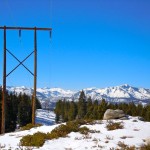
Power lines and Mount Tallac demonstrate modern conveniences and the power of nature. Photos/Kathryn Reed
Oddly, neither Sue nor I had snowshoed here before. Different off-spurs could have us exploring the High Meadow trail system for days. We’ve biked parts of Power Line, but had done zero winter outings until last weekend.
Already on the to-do list for the three of us is going farther than we did this particular day. Next time the end point will be Star Lake. That is about six miles one-way. High Meadow is about one mile below the lake. (Distances are according to the U.S. Forest Service.)
In summer 2010, the Forest Service turned the meadow into a construction zone in order to restore Cold Creek.
On our trek we make it to an earlier manmade disturbance – power lines. Power Line trail gets its name from all those overhead wires that run through the forest.
The clearing we use as a turn-around location provides spectacular views looking west to Mount Tallac, Pyramid Peak and other ridgetops in Desolation Wilderness.
Although signs are clearly posted that no snowmobiles are allowed where we are, the tracks prove the sleds have been out.
With the trail wide enough for a vehicle in places, it allows us to walk at least two across. It makes it easier to chat over the crunching of the snow.
Large conifers loom overhead, casting shadows on this gloriously sunny day. While the temperature was chilly to begin with, the exertion has us losing layers.
A vista of sorts beckons us before we reach our end point. The knoll provides panoramic views in all directions. Lake Tahoe almost looks small below the forest.
I’m ready to explore some more.
Getting to the High Meadow trailhead:
• From South Lake Tahoe, turn east onto Al Tahoe Boulevard.
• Turn right on Pioneer Trail.
• Turn left on Remington Trail. (Sierra House Elementary School is on the corner.)
• Follow signs to the end and park.
• On the trail, we veered up and to the right at times, but signs could be better.
ngg_shortcode_0_placeholder (Click on photos to enlarge.)