Angora burn trail system under construction


Updated Oct. 1 3:40pm: The Oct. 5 trail building day is canceled because of the federal shutdown.
—
By Kathryn Reed
One of the final pieces of the Angora burn restoration should be completed this fall – the trail system.
When the more than dozen miles worth of trails are finished, it will be possible to hike, ride a bike or a horse from the gun mount near the base of Echo Summit to Camp Richardson. The Long Term Angora Restoration Project encompasses only the trail network in the area that burned in 2007.
“We have laid it out for different experiences,” Garrett Villanueva, who heads the U.S. Forest Service’s trails team, told Lake Tahoe News. This means some areas will be more challenging than others. “The challenging trails off Tahoe Mountain will be rockier, they have more trail texture. We are trying to lay out the trails so they are not in a straight line, but so they follow the landscape and are interesting.”
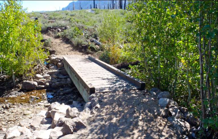
South Tahoe Association of Realtors paid for the bridge that crosses Angora Creek. Photo/Jordan Burge
The grading work must end by Oct. 15 per Tahoe Regional Planning Agency rules. If need be, what doesn’t get done this year, will be wrapped up in the spring.
The delay in doing the work is because it took so long to get the necessary permits from agencies in the basin.
Trails that had been next to stream zones have been relocated to benefit the ecosystem and help with water quality issues.
The South Tahoe Association of Realtors paid for the bridge going over Angora Creek. Some of their members, along with TAMBA volunteers and anyone else will be helping the Forest Service with a trail day on Oct. 5.
STAR created the Angora Fire Disaster Relief fund immediately after the fire. Initial donations went to members who lost their homes in the fire. The remaining funds are being used for the bridge, which will be dedicated to the residents in the area.
The trails are single track. Drainage systems have been built into the system so little maintenance it required. Undulations will naturally shed water.
A road system still remains in the area, but that is for future management needs and will only be accessed by Forest Service personnel.
Signs will be installed so people know where they are and where they can go.
A kiosk with a map of the trail system will be installed at Sawmill Road and Lake Tahoe Boulevard. This is a good access point for people needing to drive to get to the trails. Another entry point via vehicle is from the Camp Richardson side on Highway 89 where the four lanes end and there is a green gate.
Other projects to be done in the Angora burn area:
• Finish the pile burning in two units near South Tahoe High School.
• Seneca Pond restoration could begin in 2015. Phase one is to drain it and phase two is to restore the area to its natural setting – which means no pond. It is not funded yet.
• Angora Creek restoration does have funding. Next year crews will likely do some wood placement by hand. In 2015 there would be stream construction work and then work should be completed in 2017 with connection of the channel.
• There will be thinning work in the area, but it’s part of the South Shore Fuels Reduction Project and not Angora restoration work.
Notes:
• There is a trail workday on Oct. 5 from 9am-4pm. Meet at the end of Forest Mountain Road off Tahoe Mountain Road. Hard hats and tools will be provided.
• Here is a copy of the Angora trail map.

Then will we be allowed to park at the gun mount? Cars parked along the highway seem a dangerous proposition. WHY are we no longer allowed to park in the off-road, convenient, safe parking lot at the gun mount?
looks like a lot more trails being closed than built, greatly limiting getting from one place to another, unless you want to go where the new trails take you.
Does anyone know where the bridge is? They took out a perfectly good bridge last year, now they are replacing it?
I remember the meetings with the Forest Service after the Angora fire ” asking” for our input. One of the issues almost EVERYONE agreed on was to KEEP Seneca Pond! It was such a nice little ” jewel” to stop and let the dogs cool off & attracted an abundance of wildlife. We have Osgood Swamp- don’t need another one! Why do they ask our opinion & do what the want anyway? And the bridge being removed last year? When I called the Forest Service told me it was to help fish migration- funny- being that Angora Creek dries up in June most years! ” if it ain’t broke don’t fix it” applies here!
Kae, many thanks for including information about our upcoming bridge build. Great article.
http://www.staor.org/angora-burn-trail-system-under-construction/
It’ll be nice to have the Tahoe Mtn. trail that cuts across to behind Mt Rainer St. functioning again.
Does anyone know why they need to decomission the old trails before building the new ones? Maybe I just don’t know where to go but it seems like they have cut off the main road at the end of Panther but I don’t think another route has been created. Does anyone know what trails are going to be open for the rest of the fall now that the Forest Service is closed? I don’t mean to sound ungrateful and I’m excited about the prospect of new trails I’m just thinking it would have been nice to leave some trails in place until the new ones are built.
Having hiked and run those trails for years, there are a few that need to be re-routed. Several of the trails – I’m assuming that they’re “volunteer” paths – dip into the Spring water table in the meadows. Folks using the trails encounter standing water or mud and attempt to go around – thereby widening the muddy footprint of the trail.
It shouldn’t be too difficult to create bypasses to those trails. But, from what I’m seeing, the Forest Service is hellbent to put everyone on a very limited number of trails, some of which, perhaps, will be horse trails which any runner or hiker knows are ankle breakers.
My question is how the Forest Service is going to prevent new volunteer trails from arising. Perhaps there’ll be no need. Or, more likely, many of us will try to seek out the paths we used to use. Will the Forest Service, in response, start fencing the trails? Or paving them? Or sending out their well known (and becoming somewhat infamous)law enforcement rangers to keep everyone in line?