Tahoe’s mucky shoreline getting attention
By Kathryn Reed
KINGS BEACH – The problem with being able to come up with solutions for how to make the water along the shoreline of Lake Tahoe as pristine as the deep water is that there has been no monitoring done in the shallow areas. This means researchers have no data to study to come up with a cause and then an action plan.
This was the message delivered to the Tahoe Regional Planning Agency board Oct. 23 in Kings Beach. Alan Heyvaert with the Desert Research Institute in Reno presented the report that was created by more than a dozen scientists from DRI, UNR and UC Davis.
“If we don’t have monitoring programs, we can’t say anything in a quantitative sense,” Heyvaert said.

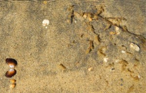
A clam shell, left, and small stringy plants are found Oct. 23 in the water at Regan Beach in South Lake Tahoe. Photo/Kathryn Reed
And without monitoring, there is no baseline from which to establish where scientists will eventually want to get back to in terms of clarity and other measurables.
This is in contrast to the overall clarity of the lake that for decades was first measured with a white dinner plate and now a Secchi disc to see how far down it can be seen with the naked eye. But that all takes place far from shore.
The document – more than 300 pages – is a framework for how to go forward with addressing what is called the near shore. It’s a scientific document, not a policy manual. The TRPA board was there to listen and not take action.
The price tag for the “Yugo model” of the monitoring system could be $400,000 per year.
But some of what is going on with other monitoring programs could be tweaked to satisfy near shore questions. That is going to be looked into. But scientists warn there is no time to waste.
“We are seeing more invasive aquatic plants. We are losing a lot of native macroinvertebrate species that are only found in Lake Tahoe,” Heyvaert said.
The group first looked at the 62 standards related to the near shore that TRPA, Lahontan Regional Water Quality Control Board and Nevada Department of Environmental Protection use. They whittled those to 38 categories deemed relevant or important. From there the study group came up with 10 metrics associated with four indicators. Those are:
• Turbidity is associated with clarity
• Light transmissivity – clarity
• Chlorophyll – clarity and trophic status
• Phytoplankton – trophic status
• Periphyton – trophic status and community structure
• Macrophytes – trophic status and community structure
• Macroinvertebrates – community structure
• Fish and crayfish – community structure
• Toxins – human health
• Pathogens – human health.
Heyvaert explained it is not a good use of time and money to measure the nutrients at the near shore, that it is better to quantify the amount of algae that is eating the nutrients. This way researchers can determine if algae is increasing or decreasing, where this is taking place and at what times of year. Then the causes can be determined and solutions found.
One of the other difficulties with ridding the shoreline of gunk is that the 72 miles are not all the same. Different problems are occurring different places.
The scientists define near shore as from the water’s edge to a minimum of 350 feet from shore and about 69 feet down. The depth is the mid-summer thermocline, or where the warm and cold waters meet.
While there are no definite reasons to why the water along the shore is mucky in places, likely contributors, according to scientists, are aquatic invasive species, pollutants entering the lake from the watershed or groundwater, stormwater, runoff from the developed and undeveloped portions of the surrounding watershed, greater vulnerability to increased temperature from climate change, recreation, existing structures, and fluctuation in lake levels.


Thanks again for great reporting. You have the knack of making complex subjects understandable for those of us without specialized knowledge or experience.
there is too much fertilizer being used
think back to the 60’s & 70’s when nobody had lawns and flower beds
It’s a bit inaccurate to write that there is “no data” on near-shore conditions: The UCD Tahoe Research Group, UNR, and DRI have collected various surveys and snapshots near shore for decades. But Dr. Heyvaert is right that no steady monitoring has been done.
It’s the tahoe keys fly over in a helicopter and you can clearly see all the brown muck coming right out of the inlet from the keys turn the keys back into a natural wetland filteration before the houses were built only way to save the lake.
I actually remember swimming in Lake Tahoe before the algae took over and you could see the very bottom of just about every part of the lake, huge trout and fish for it seemed forever. I also loved hiking to Eagle Lake and all the other great areas of the Desolation Wilderness, where I camped countless times, and made a world record jump once witnessed by several people across the river just east of Eagle Lake. Such great times. Maybe someday again soon.