Then and now: Travel over Donner Summit


Donner Summit
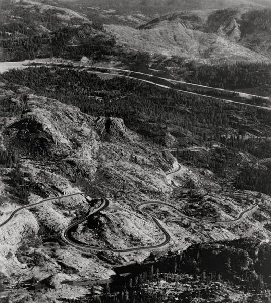
Photo/Caltrans
This single photograph from 1964 depicts the then and the now of highway travel over Donner Summit.
The twisting two-lane road seen on the lower half of the photo is historic “U.S. Route 40,” also known as part of the Lincoln Highway. Crossing Donner Summit, it passes Donner Ski Ranch, Sugar Bowl, Donner Lake, and continues eastward through Truckee then on to Reno. It also has one of the most-photographed bridges in the country, the Rainbow Bridge, the design of which includes a curve and a grade.
Highway 40 was the only access north of Tahoe to reach the Squaw Valley Winter Olympics of 1960.
In 1964, the modern Interstate 80 divided freeway opened. I-80 appears as the parallel white streaks across the top half of the photo.
Old “U.S. Route 40” is known now as Donner Pass Road.
— Bill Kingman

Good Morning Bill Kingman! The Lincoln Highway also ran thru the bay area, Pollock Pines over Echo Summit , South Shore and out into Nevada. There is still a small stretch of road out by Cave Rock that’s still called Lincoln Highway.
Interesting stuff Bill!
As always, take care, Old Long Skiis
It is a beautiful drive if you have never done it – from Hwy 80 down to Donner Lake.
Carson to Sac is the only place in the country the Lincoln Hwy split and had a north and south route. Most envision it ran from Sac to SF near Interstate 80, when in fact it looped south thru Stockton, then to Oakland, where the Oakland to SF ferry was part of the Lincoln Hwy. The terminus point was at the ocean near the Cliff House. Cross country drivers would actually drive their car into the surf to celebrate completion!
how bout this. You shared some good history about the Lincoln Hwy! Thanks for the information. I love Tahoe history and this just adds more to my rusty and creaky knowledge of the place I still call home.
Thanks for the information!
Drive carefully along Lincoln Hwy, boys and girls as that old road can be dangerous, take my word for it! OLS
OLS… Can your rusty and creaky knowledge explain why Google Maps shows Pioneer Trail as the Lincoln Highway? That has always bothered me since I live off Pioneer and thought I knew the history of it and my rusty and creaky knowledge has never heard of Pioneer Trail being a highway, just the trail out of town.
There is a stretch of the Lincoln Hwy that runs above and parallel to the current Hwy 50, but starts at Kings Canyon in Carson City and joins 50 at Spooner Summit. I’ve walked it quite a few times and the views of the Carson Valley are amazing.
SeaMoore, Lots of stories about Pioneer trail as I lived on the corner of Glenwood and Pioneer when I was in my first 3 years at STHS, 68′ thru 70′.
I’m not that sure about the Lincoln hiway route if it went down Pioneer trail but there are some neat old remnants buried in that area from earlier settlors. Bottles, cans, kids metal toys, and etc., can be found in that area.
When I was a young man, Pioneer Trail and a good portion of Al Tahoe Blvd. were dirt roads. Lot’s of hiking and biking trails all along Pioneer!
Lottsa fun! OLS
OLS… We built in ’72 here under the powerline right above Al Tahoe. We have collected lots remnants from the old dump over the years that’s now considered a “Historical Landmark”. We actually created what is now the Powerline Trail back in the day with our dirt bikes when it wasn’t frowned upon. The trails, the giant burned out cedars not to mention the sugar pines and yes… the dumps and old vehicles left to rust out make this a great area to explore.
Here’s a map showing all of the routes of the Lincoln Highway.
https://www.lincolnhighwayassoc.org/map/
Pioneer Trail!!! The original route of the Lincoln Highway circa 1913. Mystery solved. Thanks so much!
Ridiculouness! Thanks for the link about the old Lincoln Highway!!! Excellent inforrmation! Who’d ever thougt the place I played,dug for old treasures, (bottles, cans and such),rode my Scwhinn Stingray bicycle, and then later my 100cc Yamaha street bike with the knobby back tire I put on it so I could get up to Star Lake and ride the tons of trails off of Pioneer Trail that was once originally, Lincoln Highway!
Way cool! Thanks again, Old Long Skiis