El Niño expected to stay strong, finish wet
By Kathryn Reed
STATELINE – To the untrained eye the three images looked practically they same. They showed the El Niño pattern from 1982-83, 1997-98 and 2015-16.
The first two brought crazy weather to Northern California and Northern Nevada. It’s usually the first quarter of the year where the moisture really starts to fall.
“So far we’ve got out of this event exactly what we expected,” Sasha Gershunov, climate and meteorology researcher at Scripps Institute of Oceanography in San Diego, said of this winter’s weather phenomenon.
He was one of the speakers Jan. 8 at the annual Operation Sierra Storm conference, a gathering of television meteorologists hosted by Lake Tahoe Visitors Authority.
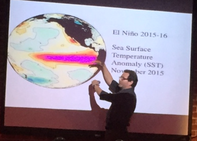
Sasha Gershunov points to the pink area that is El Niño. Photo/LTN
A difference this go-round compared to the last two significant El Niños is that the world is a warmer place. This could make for a nasty situation if in March the moisture in the Sierra becomes rain on top of the snowpack. It could cause flooding as well wash away the white stuff that is needed to fill reservoirs downstream.
It’s especially concerning because the signals are for the snowy season to end on a particularly wet note, he said.
For now, the models point to this being one of the strongest El Niños on record, with no sign of slowing down any time soon.
Much of Gershunov’s talk focused on the formation of El Niños, which start off the coast of India. Warm ocean water is pushed toward Peru. He believes as long as the Earth has been in its current configuration there have been El Niños.
“It’s a dance between the atmosphere and the ocean,” he said. “Unless they act in unison, an El Niño cannot happen.”
They are cyclical, occurring about every two to seven years.
The warming of the Pacific Ocean near the equator is where an El Niño is strongest. California and Nevada are essentially experiencing the ripple effect.
“El Niño is just one thing that is going on in the atmosphere. There are several configurations a storm track can take,” Gershunov said.
When the 1982-83 El Niño hit it took weather and climate experts by surprise.
“We didn’t have the models or observations. People realized we better learn how to predict these things,” Gershunov said.
Fifteen years later the science and technology got it right, the same with this season’s El Niño.
While the science has improved through the years, there is room for improvement.
“Unless there is some sort of breakthrough, there is a prediction barrier in the spring,” Gershunov said. That’s why it isn’t until summer that meteorologists are able to forecast an El Niño for the coming winter.