Escaping Tahoe for hike on Prison Hill
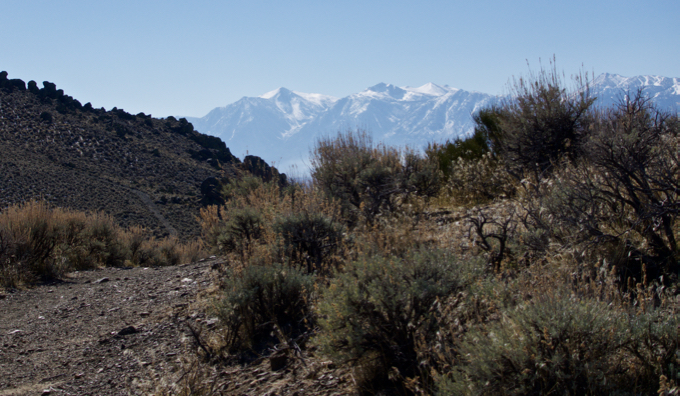
Walking among the sagebrush the Sierra seem to loom large. Photo/Kathryn Reed
By Kathryn Reed
CARSON CITY – We were held captive on our hike at Prison Hill. Captive by the beauty and number of trails we could explore.
It was a first for the three of us to experience this section of Carson City. There are so many trails in the Prison Hill Recreation Area and Silver Saddle Ranch that we will be back.
It was mid-February when we ventured off the hill. The openness – as in no trees – makes this area ideal to venture to any time of year but summer. It would be blistering hot then. When we went there wasn’t snow at the lake, so hiking outside the basin seemed like our best option for playing outside.

For the most part signage is good. Photo/Kathryn Reed
Even though we were in the capital city, at times it felt like we were in a remote location of the Silver State. The terrain is rugged and beautiful. Sage is the predominate plant protruding from the otherwise barren landscape.
At times the Sierra are in view, providing a snowcapped magic and complete contrast to where our hiking boots were leaving tracks.
Looking east it was more desolate. Trails – not sure if they were hiking, 4-wheeling, equestrian or biking – could be seen in the distance. Just another place to put on the to-do list.
Where we were a lone horsewoman passed us. People were scarce. That was one of the nice things about the hike – so few people on a weekend. Dogs being permitted was an added bonus.

Carson City seems to go on and on from Prison Hill. Photo/Kathryn Reed
Yes, ample views showed the sprawl of Carson City, but there is so much beauty around that the development was not a distraction. On the north side the prison for which the hill is named finally came into view.
This is where the annual Escape from Prison Hill Trail Race is staged. This year’s event is April 21. There is a 5K, 10K and half marathon.
Tombstone looking rocks have “Escape Route” etched on them. Not knowing where we’d be escaping too, we kept on our preplanned route.
We started on the north side of the West Loop, then hooked up with the North Loop. In all it was just less than 5 miles. The start is nearly straight up – no switchbacks. It gets easier from there. Poles would have been welcome coming down.

Bring water — this trail doesn’t have any. Photo/Kathryn Reed
—–
Getting there from South Lake Tahoe:
Take Highway 50 east to Carson City.
Turn left at the bottom of the hill onto Carson Street. Turn right on Clearview Drive. Go to the end. Signage is good.