5 loop road alternatives to be studied


By Kathryn Reed
STATELINE – With a near unanimous vote, the Tahoe Transportation District on Friday selected five loop road alternatives to study in the environmental documents. But what that assessment will look like is not expected to be released in draft form until January 2015.
Angela Swanson, South Lake Tahoe’s rep to the TTD board, voted the council’s preference April 12 when she was the lone dissenter. While she expressed the city’s desire for a loop road and to work with the partners to make it happen, she said because the majority of the council takes issue with one of the alternatives, she had to vote no.
Fellow TTD board member and Douglas County rep Nancy McDermid gave her a bit of schooling in policy and procedure; saying how it’s normal to not like all alternatives in any document, but that this is the democratic practice and it’s how prejudices get ironed out.
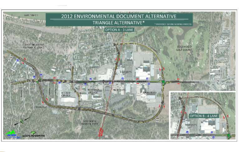
This triangle alternative is the preferred route for the loop road on the South Shore.
But McDermid doesn’t attend South Tahoe council meetings to know that this board wants to act united and not fractionalized. It also has no problems telling other entities how to do their job.
The Tahoe Transportation District – not the city, not Caltrans, not NDOT – drives the loop road.
This summer fieldwork will be done to help gather information that will be used for the environmental analysis. Then in 2014 the analysis will be done, with a draft coming out in early 2015.
The contentious alternative for the city is what is now called Alternative 2 with options. It would still take out the buildings to the west of the intersection of Highway 50 and Pioneer Trail near the state line.
The triangle alternative is deemed the preferred alternative. It would start about 500 feet west of that intersection at the two vacant lots on the highway that the city owns. Fewer businesses are likely to be demolished with this scenario.
Both of these alternatives require right-of-way acquisitions and displacement of businesses and residents.
The differences and impacts will be part of the environmental analysis, which looks at the environmental, social and economic effects of each alternative.
Both of these routes have Highway 50 going behind the Village Center, Harrah’s and MontBleu, with a two-lane roundabout at the intersection where it connects with present-day Highway 50 on the eastern side in Stateline.
In the analysis consultants will look at how narrow the current highway through the casino corridor could be, how wide sidewalks could be, and what median landscaping would work. That road would then be a city street – maintained by South Lake Tahoe and Douglas County where applicable.
The goal of the loop road is to create a complete street design to replace today’s highway, move the highway out of what proponents want to become a more pedestrian friendly area, create an area where events could be staged, and have an aesthetically pleasing area for locals and tourists.
McDermid said she would like planners to look at the possibility of separating cyclists from motorists as is done in many parts of the world, but is not common in the United States. This would mean a lane of car traffic, then a curb, then a bike lane, then another curb with sidewalk, and the businesses.
The other alternatives include a skyway that would be an elevated area near the casinos. This was included to show a route with less right-of-way needed to be secured.
McDermid asked about clearing snow and where the run-off would go. The concept was not taken seriously by the consultant or those in the room, as laughter accompanied any talk of this suggestion. Still, though, what the board voted on was that the alternatives were worth studying and represented diversity and input from the public via a series of meetings.
Another alternative is the one-way triangle that has traffic going in a circle, but creates more state highway coverage and does not create much of a streetscape.
As is customary, a do nothing alternative is included.
Having the loop road go on the lake side is not being considered, nor was it part of the economic analysis.
A business group was convened to study that economic report. It was originally tasked with providing peer review, but that did not happen. Instead, the outcome was the parroting of the project’s goals – create a more walkable, bikeable community, where people want to linger, spend money and events can be put on.
Going forward a citizens’ committee will be created with the preliminary desire to get input from people not just in the state line area. This is because whatever does or does not happen with the loop road will impact everyone who lives on the South Shore in terms of driving through the area, shopping, dining, increased-decreased tax dollars, construction delays, and the overall future of that section of the community.

DO NOTHING ! ! ! This loop road proposal has the local businesses seeing red. It’s not that the present situation is very good. It’s that the loop road will not likely live up to the expectations of improving business and other matters significantly. Virginia City has had one road going straight through town for 100 years. That road is part of the charm of Virginia City. The construction that will result, if this loop road is built, will be two years of traffic misery in the casino corridor. Let’s be realistic. The only periods of troublesome traffic comes during a few peek tourist periods per year. We can continue to deal with that. If you think this traffic is bad, go try commuting across the Bay Bridge in S. F. They deal with much worse traffic every day.
What is the rationale for the road going to Edgewood, then turning left up Stateline Ave, and spitting out the traffic right back onto the slow pedestrian zone? Why would those roads need to be included in the plan? Seems like going behind Harrah’s and Montbleu with a highway should be enough. This picture with the road popping out makes it look like the pedestrian area is in front of the casinos, not in front of the hole or The Village, it is hard to see the map, as it’s pretty small.
It should be one continuous main street, from Lake Pkwy to Park Ave, it should not look like it is only on the Nevada side.
At least it looks like it’s avoiding disturbing too many businesses.
Access for delivery trucks really needs to be considered, as does snow removal.
all for the Greed and Glory of State Line
Wheeee! Another study! More consultants!
Stateline Blvd. should be left as is today. It is primarily a path for pedestrians and horse drawn carriages. We don’t need to add higher traffic levels to connect to the Edgewood resort.
I say forget about the loop road. The goal: “The goal of the loop road is to create a complete street design to replace today’s highway, move the highway out of what proponents want to become a more pedestrian friendly area, create an area where events could be staged, and have an aesthetically pleasing area for locals and tourists.”
To achieve this goal, it is not necessary to have a loop road. I feel it is like trying to force a square peg in a round hole. Seems like a frantic whirlwind of activity to grab ahold of $64 million dollars. As far as I’m concerned, we don’t need it and I don’t want any part of it. Anyone else feel this way?
I do not get it either. There are lots of little things that could be done (Mostly by the Casino’s) to take better advantage of the space surrounding State Line. What the Tahoe Basin does not need is more big roads.
I would like to see them start digging some underground. Or even setting aside a common area to manage all the big delivery of supplies. Why does each property have to have its own big truck loading docks?
TahoePizzaEater…If we had a main street with the charm and authentic feel of Virginia City, I’d agree with you. But, we don’t. What we have is a stretch of dilapidated hotels/stores, and a cheezy strip mall feel – which is quite the opposite of what “ski towns” that are doing well have.
Creating a pedestrian friendly area with limited traffic and a re-beautification of that stretch would help this area immensely. It will also add a place for events down town. Doing nothing will not accomplish that. I don’t know the best solution but I do know that something needs to be done. We can’t be scared of change and progress.
Scott I shouldnt but I will ask. How?
Fix the hole FIRST. Why deflect our attention? That eyesore is dragging down the value of our town, and we must address it before we start redirecting traffic. Let’s open a pathway alongside an empty lot. This community needs to pull it’s head out from staring at the T-bone.
Heaven forbid that there ever be any kind of change in South Lake Tahoe-after all, that might cost money, might be an inconvenience, and apparently worst of all-it would be a change. Keep everything just like it is, in fact, let’s just return anything that’s ever been upgraded back to its former condition so it can better blend in what’s old, rundown and unattractive. Who needs upgrades like Lakeview Commons, or sidewalks, or streetlights, or methods of collecting filthy water from Highway 50 to infiltrate the runoff so cleaner water enters Lake Tahoe, or traffic that may actually move instead of idling at stoplights discharging additional amounts of choking exhaust into the air, or safe places for pedestrian tourists to walk in the commercial core–let them play “frogger” while trying to cross the Highway from one business to another to spend their money. Does South Lake Tahoe really need to make any more revenue off those pesky tourists, and does it really need to make improvements? Just rip all that newer stuff out which so many people say they hate so much and then we can go back to the 1960’s, 70’s, and 80’s. Looking forward and making changes is just too hard and too scary.
Toughen Up: I think the issue with the hole is it’s still tied up in legal limbo. It’s not like we can just jump in and fix it tomorrow. Moreover, these plans for the Loop aren’t for tomorrow either. This is planning for years down the road. We’re talking about Drafts not even coming out for 2 years so it will be a while before shovel meets dirt…
With that being the case, this is the time to start making our plans for the future. Why wait and do nothing while other ski / resort towns continue to offer things that tourists want and we don’t have?